Trail Walking Saint-Antoine l'Abbaye - saint Antoine l abbaye - Photo
 nano38
nano38

User

© OpenStreetMap contributors
Length
Length
6.9 km
Max alt
Max alt
499 m
Uphill gradient
Uphill gradient
181 m
Km-Effort
Km-Effort  
9.3 km
Min alt
Min alt
350 m
Downhill gradient
Downhill gradient
183 m
Boucle
Boucle
Yes
Creation date :
2020-07-05 09:01:09.967
Updated on :
2020-07-05 11:08:29.463

(1 Reviews)

Walking
Walking
1h52
Difficulty : Very easy

Scan this QR Code to open this trail in the SityTrail application

FREE GPS app for hiking

Logo SityTrail SityTrail

IGN / Geographical institutes

Download SityTrail from the App Store Download SityTrail from Google Play

Logo SityTrail SityTrail World

The world is yours!

Download SityTrail from the App Store Download SityTrail from Google Play Download SityTrail on Huawei AppGallery

About

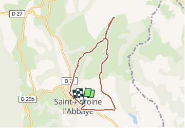
Trail Walking of 6.9 km to be discovered at Auvergne-Rhône-Alpes, Isère, Saint-Antoine l'Abbaye. This trail is proposed by nano38.

Elevation profile

Positioning

Country:
France
Region :
Auvergne-Rhône-Alpes
Department/Province :
Isère
Municipality :
Saint-Antoine l'Abbaye
Location:
Saint-Antoine-l'Abbaye
Start:(UTM)
674323 ; 5004732 (31T) N.

Comments

Please log in to post a review or rate the element


on a bien apprécié votre parcours tout en l agrementant merci


Trails nearby

Trail Mountain bike Chatte - De Chatte à St Antoine en passant par Chevrière - Photo
Mountain bike
gilder89

Mountain bike

Very difficult
(1)
Chatte, Auvergne-Rhône-Alpes, Isère, France
44 km | 60 km-effort
3h 53min
Yes
Trail Walking Roybon - Dionay - Photo
Walking
crocau

Walking

Difficult
Roybon, Auvergne-Rhône-Alpes, Isère, France
9.6 km | 12.1 km-effort
1h 54min
Yes
Trail Mountain bike Chatte - chemin du tram part1 - Photo
Mountain bike
Julien Rodriguez

Mountain bike

Very easy
Chatte, Auvergne-Rhône-Alpes, Isère, France
11.4 km | 14.1 km-effort
1h 16min
Yes
Trail Walking Saint-Antoine l'Abbaye - st. Antoine l'Abbaye - Photo
Walking
Bgi

Walking

Easy
Saint-Antoine l'Abbaye, Auvergne-Rhône-Alpes, Isère, France
21 km | 28 km-effort
5h 36min
Yes
Trail Walking Saint-Antoine l'Abbaye - cap'r à Dionay - Photo
Walking
bpc

Walking

Easy
Saint-Antoine l'Abbaye, Auvergne-Rhône-Alpes, Isère, France
8.7 km | 11.4 km-effort
1h 16min
Yes
Trail Walking Saint-Antoine l'Abbaye - Lac Chapaize / St Antoine - Photo
Walking
Gaillardenis

Walking

Medium
Saint-Antoine l'Abbaye, Auvergne-Rhône-Alpes, Isère, France
7.1 km | 9.4 km-effort
2h 7min
Yes
Trail Walking Saint-Antoine l'Abbaye - Bourgeonnière départ Le Mouchet - Photo
Walking
brigitBB26

Walking

Difficult
Saint-Antoine l'Abbaye, Auvergne-Rhône-Alpes, Isère, France
11.4 km | 14.8 km-effort
4h 33min
Yes
Trail On foot Saint-Antoine l'Abbaye - Saint Antoine l'Abbaye - Photo
On foot
JacouBrijou

On foot

Medium
Saint-Antoine l'Abbaye, Auvergne-Rhône-Alpes, Isère, France
21 km | 28 km-effort
6h 22min
Yes
Trail Horseback riding Saint-Antoine l'Abbaye - J4_boucle_St Antoine l'Abbaye foret de Thivolet 17/4 - Photo
Horseback riding
Juyagan

Horseback riding

Difficult
Saint-Antoine l'Abbaye, Auvergne-Rhône-Alpes, Isère, France
26 km | 34 km-effort
4h 31min
Yes


Close
My subscriptions